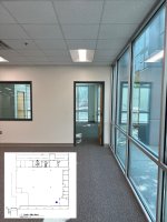
Hey there! This is a fantastic idea, and that mockup made it really easy to picture.

The live camera overlay with a Maps-style navigation indicator isn't something we can do today. But the foundation you're describing — uploading a plan and pinning photos to exact spots on it — is something our team is actively tinkering with right now. I can't make any promises, but feedback like this helps shape what we build next, so thank you for taking the time to write it up.
In the meantime, here are a couple of things that get you partway there:
Map This Photo might be the closest thing to what you're after. Open a photo, tap the Map Icon, and you'll see a pin for where it was taken
plus the direction the photographer was facing. That's the "which way was this shot looking?" piece you mentioned, just on a satellite map instead of over the drawing.
Here's how it works.
Turn on GPS + date/time stamps so every photo carries its own location context for anyone reviewing later.
Steps here.
Upload the drawing as a Project Document, then use Tags (or a quick annotation on a copy of the plan) to label areas — "North Elevation," "Grid C4," etc. Tag your photos to match, and someone who's never been on site can filter to an area and know exactly what they're looking at.
Draw a geofence when you create the project so photos stay tied to the right site — handy on larger jobs.
Not quite your ask, but it'll get your viewer oriented today. Keep the ideas coming!